You can select the options used to display an ESRI Map custom widget using the ESRI Map Properties dialog box.
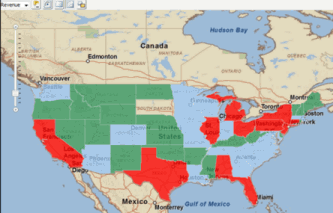
The ESRI Map custom widget allows you to display information about locations in a map as colored regions or map markers. An example of an ESRI Map widget with colored regions is displayed in the image below.
You can:
Color-code regions displayed in the map based on the value of a metric
Change the display of map markers in the widget based on the value of a metric
Display an Information Window with additional information about a location when a user hovers the cursor over a map marker in the widget
Zoom in and out of the map to customize your display
For more information on the ESRI Map widget, including steps to enable the plugin used to display the widget and data requirements for the attributes used to provide the location information for regions and map markers in the widget, see the GIS Integration Help.
The following options are available:
Show Markers: Select this option to display locations on the map using map markers.
Attribute: Select the attribute you want to use to display map markers in the widget. This attribute must contain separate attribute forms with the latitude and longitude of each map marker you want to display.
Select Latitude: Select the attribute form you want to use to provide the latitude of each map marker.
Select Longitude: Select the attribute form you want to use to provide the longitude of each map marker.
Show Areas: Select this option to display locations on the map as colored regions.
Attribute: Select the attribute you want to use to provide the location information for the colored regions in the map. For a detailed explanation of the data requirements for this attribute, see the GIS Integration Help.
Related topics